Castlemaine Gold Project
Since its ASX listing in early 2017, Kalamazoo has continually investigated the acquisition of mineral assets with inherent potential that can be exploited by advanced exploration and development technologies. Following this strategy, Kalamazoo identified the highly prospective Bendigo Zone in Victoria as its key focus for securing an extensive and promising tenement position.
Kalamazoo’s Project Generation Team identified an opportunity to acquire the Castlemaine Gold Project at Castlemaine at minimal cost. Following which, the Company’s due diligence and technical assessment has confirmed Kalamazoo’s belief in the project’s significant potential.
Kalamazoo recognises the opportunity it has to cost effectively add modern exploration techniques at the Castlemaine Gold Project, to enhance its understanding of the structural controls of mineralisation that are critical to drill targeting and unlocking the true potential of this style of deposit.
The Castlemaine Gold Project is in a supportive mining region which is becoming increasingly active with significant exploration and development success across multiple projects including Fosterville, Tandarra and Costerfield.
Strategically, the Castlemaine region is well supported with a number of gold processing plants located within 80km haulage distance of the Castlemaine Gold Project.
Tenements
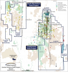
The Castlemaine Gold Project consists of two exploration tenements, EL006679 (“Wattle Gully”, ~70km2) and EL006752 (“Wattle Gully South”, ~218km2).
EL6679 lies immediately east and south of the town of Castlemaine and covers almost the entire historic Castlemaine Goldfield whilst EL6752 lies to the east and south of EL6679 and covers regional geological structures known to be associated with gold potential. EL7112 lies adjacent and to the east of EL6752.
Figure 3: Regional Geology, Structures, Gold Projects and Castlemaine Gold Project Tenements
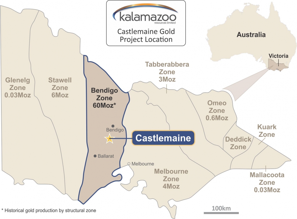
Figure 1: Castlemaine Gold Project Location
Figure 2: Central Victoria Gold Project Tenure
Community Engagement and Environment
Kalamazoo considers community engagement important to all its activities and is focused on developing relationships with all community stakeholders, including government agencies, local communities, interest groups and employees.
Kalamazoo is vitally aware of its environmental responsibilities regarding the local communities and the preservation of the natural biodiversity in all areas and states within which it operates. Consultation with local councils and stakeholders will be an early and ongoing priority.
Kalamazoo believes in minimising or mitigating any detrimental effects that works may have on the environment. This will be achieved through responsible planning and management of company activities and as a minimum standard, working within the Victorian Code of Practice for Mineral Exploration.*
*http://www.earthresources.vic.gov.au/earth-resources-regulation/licensing-and-approvals/minerals/guidelines-and-codes-of-practice/code-of-practice-mineral-exploration
Local Community/Media FAQs
What impact will KZR’s exploration activities have on the town?
- KZR’s strategy is to ensure minimal disturbance to the local Community and avoidance of sensitive heritage sites.
- Given that the majority of KZRs exploration area is located on either Crown Land, Castlemaine Diggings National Park or pine plantations, we anticipate little to no direct impact on individual landowners.
- If KZR’s exploration activities show promise, the town could expect some positive economic benefits such as a potential boost in local employment, business opportunities etc.
Will you disturb heritage areas/sites?
- No – KZR’s strategy is to ensure minimal disturbance to the local Community and avoidance of sensitive heritage sites.
- KZR accepts and respects the fact that the local Community places a high value on the local heritage sites and are sensitive to any proposed exploration that may disturb them.
Will KZR rehabilitate its explorations sites?
- All exploration programs including those that involve any ground disturbance such as exploration drilling cannot commence until first approved by the Victorian Government.
- It is a Government statutory requirement that KZR complete appropriate rehabilitation of any disturbed sites such as drilling pads and access tracks.
- It is important to note that Rehabilitation Bonds are first lodged with the Government before any ground disturbing exploration works can commence.
- Failure to comply with the Victoria Government’s Mineral Resources Act may result in forfeiture of exploration licences and financial penalties.
What job/business opportunities will there be for locals?
- KZR is committed to supporting the local Community and will endeavour to source local labour, contractors and supplies whenever possible.
- It is important to note that early stage exploration projects usually only require limited local labour and supplies in the initial stages, due to the small scale and short duration of focussed exploration activities.
Will you be paying compensation to local landowners?
- In the unlikely event that a local landowner is directly impacted by our exploration activities KZR will pay fair and reasonable costs to compensate the landowner accordingly.
What happens should KZR have a gold discovery?
- In the event of a commercial discovery, it typically takes at least 3-5 years before mine production could begin. During this time numerous tasks need to be successfully completed before mining can commence such as mine planning and design, economic modelling, environmental assessments and approvals, Government regulatory approvals, funding etc.
In the event of a discovery will KZR develop a large open cut mine?
- No – KZR’s current strategy is to explore for commercial deposits of gold that can be mined at depth through underground mining methods.
- It is important to note that no mining is allowed in the top 100m depth for a large proportion of the exploration area which is covered by the Castlemaine Diggings National Park.
Will KZR be re-starting the Wattle Gully mine?
- KZR currently has no plans to restart the Wattle Gully Mine, rather viewing greater exploration potential in the surrounding region.
Bendigo Zone
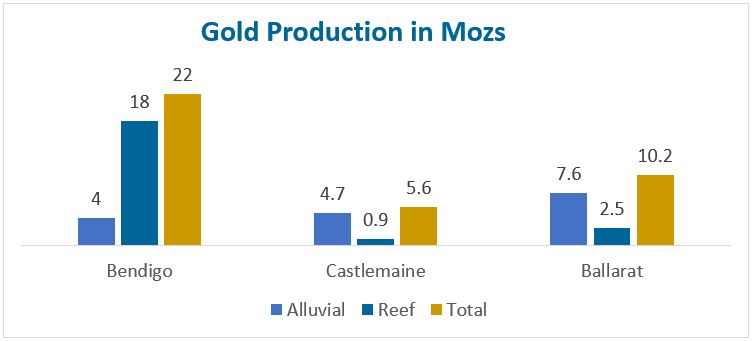
The Bendigo Zone is the second highest producing goldfield in Australia having produced an estimated 60Moz from alluvial and continuous quartz reef mining activity from 1853 to 1954 (Willman et al 2002, Geology Survey Victoria, Report 121). From within this zone, the Bendigo Goldfield produced an estimated 22Moz primarily from quartz reef mining. The Ballarat Goldfield was the second largest with an estimated 10Moz produced (Figure 4).
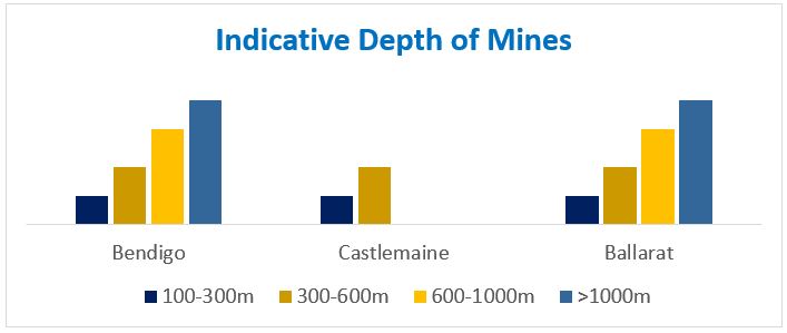
Castlemaine was the next richest goldfield in Victoria, having produced 5.6 million ounces since 1851 from both alluvial and underground sources (Figure 4). Previous mining and exploration at Castlemaine targeted shallower areas primarily within 400m of the surface. (Willman et al 2002, Geology Survey Victoria, Report 121).
The recent exploration success that has been achieved by Kirkland Lake Gold (ASX: KLA) at the Fosterville Gold Mine demonstrates the substantial gold prospectivity that the Victorian systems can possess at depth (Fosterville Mineral Reserves increased approximately 247% from December 31, 2016 to 1.7Moz @ 23.1g/t – refer to ASX: KLA 3 May 2018).
Successful exploration north of Wattle Gully along the Whitelaw Fault Corridor by companies such Catalyst Metals (ASX: CYL), Navarre Minerals Limited (ASX: NML), Hancock Prospecting Pty Ltd and others has also resulted in a number of significant new gold discoveries such as Sebastian North, Tandarra, Four Eagles and Macorna Bore (Figure 2). Also, the recent deep drilling success by the Canadian listed Mandalay Resources Ltd (TSX: MND) beneath its operating Costerfield gold-antimony mine is also very encouraging for Kalamazoo as it lies to the north east of the Castlemaine Goldfield (Figure 2). Centennial Mining Limited (ASX: CTL) is also operating its Porcupine Flat gold processing facility at Maldon, only 20km to the north west of Wattle Gully, which could also be a potential processing facility.
The current focus on the highly prospective Bendigo Zone has led to other leading ASX listed gold companies targeting potential new gold discoveries in the area. Recently Chalice Gold Mines (ASX: CHN), announced it had secured an extensive strategic position in the highly prospective northern Bendigo Zone via exploration licence applications covering a total area of 3,350km2 (refer to ASX: CHN 26 April 2018) with a focus on regional faults, interpreted to be the controls for significant gold mineralisation.
Figure 4: Historical Gold Production Victorian Goldfields.
(Source: Modified from CGT Internal report: G Scanlan, Master Presentation Document, 2007)
Figure 5: Average Depth and Number of Mines, Central Victorian Goldfields
(Source: Modified from ASX: CGT Investor Presentation October 2006)
Castlemaine Gold Project
The Castlemaine Goldfield is located approximately 100km northwest of Melbourne and is well serviced with infrastructure, available work force and by a network of roads, railway and air services. The project area lies within easy distance of the major regional population centres of Ballarat and Bendigo.
In comparison to the other fields within the Bendigo Zone, the Castlemaine Goldfield has not been tested comprehensively at depth leaving open the prospect of repetitions of mineralisation at deeper levels.
The previous Castlemaine mining and exploration leases were controlled by Singapore-listed LionGold Corp Ltd (A78.SI) following its acquisition of then ASX-listed Castlemaine Goldfields Limited (ASX: CGT) in 2012. As part of this transaction, LionGold also acquired CGT’s operating Ballarat Gold Mine and since this time has largely focused its exploration efforts on near-mine targets around Ballarat.
Table 1: Comparison of Victorian Gold Regions
(Modified after Ballarat – Annual Qualified Persons Report for the Ballarat Gold Mine, Australia for the Year Ended 31 March 2017, Petrie et al. and Fosterville – Report on the Mineral and Mineral Reserves of the Fosterville Gold Mine, 2017, for Kirkland Lake Gold Ltd, Fuller et al)
Limited Recent Exploration
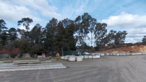
Kalamazoo has also been able to secure from Castlemaine Goldfields Limited (“CGT”, the previous tenement holders) the Project’s 200GB+ database, including 3D models of various deposits and the entire drill core farm (Figure 6). The replacement value of this dataset is estimated by Kalamazoo to be well in excess of $20 million.
Only limited exploration has been conducted within the Castlemaine Goldfield since it was acquired by LionGold Corp in 2012. Certain modern exploration techniques, for example gravity and seismic surveying, have not been utilised within the project area but have proven to be very effective at Kirkland Lake’s Fosterville Gold Mine.
Figure 6: A portion of the extensive historical core farm acquired from CGT
Geology
The Castlemaine Goldfield is located within a north trending mineralised zone approximately 10km long and 4km wide within the highly mineralised Bendigo-Ballarat Zone of the western Lachlan Fold Belt. The Bendigo-Ballarat Zone is bounded east and west by the regional north trending Mount William and Avoca Faults respectively. In turn, the north trending Taradale and Muckleford Faults bound the Castlemaine Goldfield and the licences east and west, respectively.
Folded and faulted Lower Ordovician Castlemaine Group turbiditic sediments, predominantly underlie the licence area. These were deformed into regionally upright, tight, chevron-style folds. A strong axial plane cleavage has developed and folds are truncated by numerous reverse faults.
The important Schicer Gully and Harris Faults divide the Castlemaine Goldfield into two structural domains with the western domain (west of the Schicer Gully Fault) containing most of the major mineralised structures.
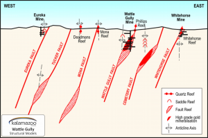
Mineralisation is predominantly associated with north striking quartz reefs and west dipping reverse faults with adjoining spur zones (Figure 8).
Figure 8: Geological-structural setting of Chewton and Wattle Gully Fault systems
(modified from ASX: CGT March Quarterly Update, 2007)
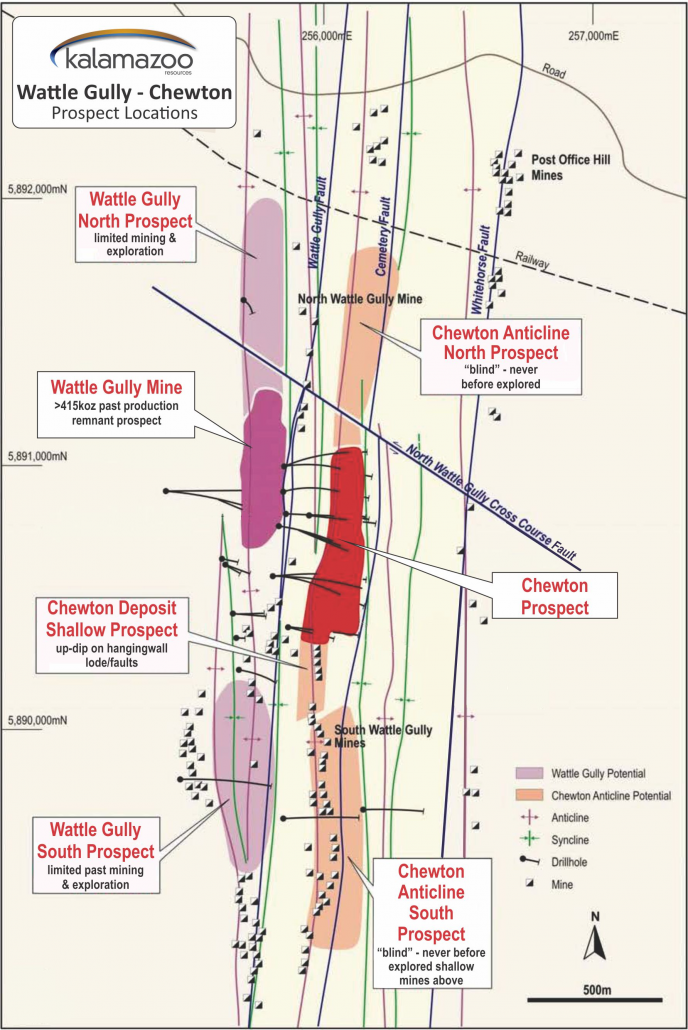
Figure 7: Project Location of Wattle Gully tenement and gold prospects
(modified from ASX: CGT, June 2008)
Wattle Gully Mine
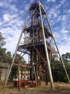
The Castlemaine Gold Project is located approximately 5km south east of the town of Castlemaine and the Wattle Gully mine (Figure 9) operated between 1934 and 1969.
Gold mineralisation occurs as free grains in massive or laminated quartz reefs on west dipping faults, or as bedding discordant spur quartz veins. Mineralised quartz exhibits stylolitic ‘laminated’ textures with pyrite, arsenopyrite, base metal sulphides and numerous instances of visible gold.
Figure 9: Wattle Gully Gold Mine Headframe, 2018
Prospective Areas of Interest
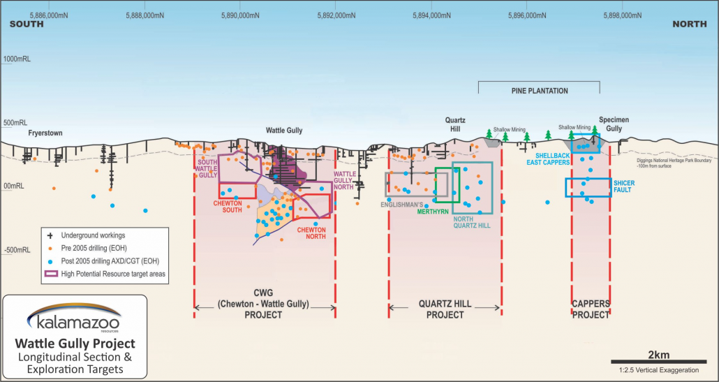
An initial review by Kalamazoo of the Castlemaine Goldfields confirmed that the Wattle Gully, North Quartz Hill, Eureka Vineyard and Cappers/Shellback projects were important sources for gold production (Figure 10). Kalamazoo intends to initially focus on these areas for their potential to develop exploration targets, most likely at depth, via a dedicated techncial review process which is well under way.
The success of Kirkland Lake’s Fosterville Gold Mine with known gold mineralisation to 1,350m depth (refer to Scotiabank Mining Conference, December 6, 2016, Kirkland Lake Gold), the modern virgin discoveries of Tandarra and Four Eagles along the Whitelaw Fault corridor (Figure 2) and the nearby development of Mandalay’s Costerfield gold-antimony mine, indicate that successful exploration and development of profitable gold mines is possible in Victoria.
Kalamazoo believes the combination of new exploration techniques and the knowledge that will be derived from the analysis of the extensive database and core farm will permit the company to outline an effective exploration strategy to identify areas with high grade gold potential.
Figure 10: Long Section of the Wattle Gully Project Area and gold prospects
(Modified from ASX: CGT AGM 2009 Presentation)
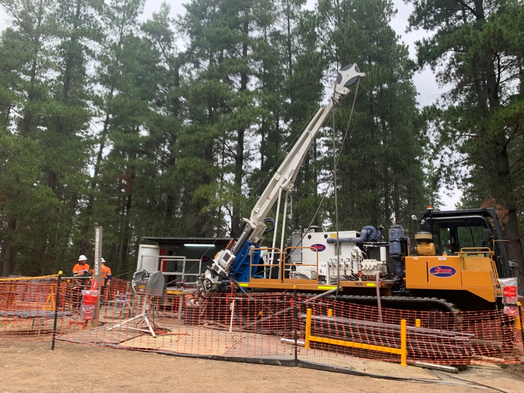
Figure 11: Deepcore Diamond Drill Rig at Castlemaine Gold Project, November 2019
Current Work Program
Kalamazoo is currently conducting ongoing ground geophysics, surface geochemistry surveys, diamond drilling programs and field reconnaissance – all at various stages.
Competent Persons Statement
The information for the Victorian Projects as well as the DOM’s Hill, Marble Bar and Pear Creek Projects in Western Australia is based on information compiled by Dr Luke Mortimer, a competent person who is a Member of The Australian Institute of Geoscientists. Dr Mortimer is an employee engaged as the Exploration Manager for the Company and has sufficient experience which is relevant to the style of mineralisation and type of deposit under consideration and to the activity which he is undertaking to qualify as a Competent Person as defined in the 2012 Edition of the ‘Australasian Code for Reporting of Exploration results, Mineral Resources and Ore Reserves’. Dr Mortimer consents to the inclusion in this document of the matters based on his information in the form and context in which it appears.
The information in this release relating to the exploration data for the Mallina West and Ashburton Gold Projects is based on information compiled by Mr Matthew Rolfe, a competent person who is a Member of The Australasian Institute of Geoscientists. Mr Rolfe is an employee of Kalamazoo Resources Ltd and is engaged as Exploration Manager – Ashburton Gold Project for the Company. Mr Rolfe has sufficient experience which is relevant to the style of mineralisation and type of deposit under consideration and to the activity which he is undertaking to qualify as a Competent Person as defined in the 2012 Edition of the ‘Australasian Code for Reporting of Exploration Results, Mineral Resources and Ore Reserves’. Mr Rolfe consents to the inclusion in this document of the matters based on his information in the form and context in which it appears.

